Best Website for Herkimer Diamond Information
Last Updated:

About this Webpage:


Free Website Where Herkimer Diamond Enthusiasts Share Information with the Public
Scroll down
Dr.C. did two talks at the Herkimer Diamond Festival (July)which are in a Youtube movie. The research on the Herkimer District is in need of samples and photos.
How can you help? Visit the "how to help" page.


A Very Generalixed Description of the Zonation in the Herkimer District
In the future we will have more information about the behavior of these zones, and their occurence at each of the mines in the district. What is presented here are only preliminary findings.
The relationship between each of these zones, their timing in relation to each other, and the processes that caused their unique features are all questions that have yet to be researched in detail. The zones also vary in behavior from deposit to deposit across the district. But below is a generalized summary of the layering ( preliminary findings ).
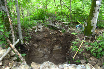
Pocket Zone - Contains pockets ranging in size from 1/2 a foot in diameter up to several feet. The shape of the pockets is not consistant across the district, but the "dome and dougnut" model has been proposed for the Middleville deposits.
This author also believes that this zone may repeat as a zone of smaller pockets above the larger pocket zone. This is seen at the TCR location. And it may repeat below the druze zone (seen at DA). There is also a small pocket zone and a large pocket zone at HH.
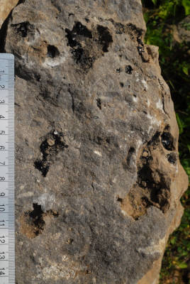
It is a layer of many small holes, dolomite lined, and some with the black carbon material and no druze! Occassionally there will be a small Herkimer diamond, or a couple, within one of these holes, or vugs. This is the common collecting rock for tourists at the Herkimer Diamond Mine in Middleville, NY. A photo of the vug zone at TCR is provided on right.
Please note that the above sequence is a very generalized sequence and is subject to updated information as more field evidence is gathered. It is presented here for public enlightenment, but should not be considered the "final word" on the subject. The fact that such zonation is observed, that it changes in character across the district and that some features remain fairly consistant across the district are remarkable points.
We do not know very much about the nature of the zones across large distances, anything more than 10 to 50 feet. The nature and behavior of the zones and layers can be observed across a long horizontal surface (100s of feet) at the Benchmark Hanson Quarry. Unfortuantely no researcher is allowed in there to study them in detail.
The pocket zone has been mined in Middleville along 100s of feet, in two mines. Because of this we have some idea of how that one zone behaves. But the mining is following a flat intersection with the zone and thus it presents as "thin slices" through the zone giving us only that type of view at any moment in time. In addition little attention has been paid to the details, while most of the attention has been on "getting the sparkle". A more detailed gathering of information, with documentation, would be needed during the mining in order to understand the zone behavior.
In a district that covers more than 600 square km you can imagine that examining 50 feet of exposed rock is only a tiny sample. It is quite likely that the zones and layers have more variability than has been documented thus far.
This page will be updated when more information is made available.
W. David Hoisington, Ph.D.
More pocket photos are located on each mine's web page - click Directions at the top.
July, 2011